These settings are the fourth step in getting NEO Planner up and running.
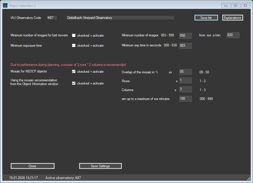
Additional parameters for planning can be entered here.
Mosaics should only be activated if the plan consists exclusively of NEOCP objects which, due to an excessively high 1-sigma value (visible with the S function in Revise),
clearly do not fit within the equipment's field of view. Therefore, reduce the planned objects in Execute Planning accordingly before activating the mosaic function.
go to top
Special recording settings
Minimum number of images for fast movers
In order to find faster objects more reliably with the Tycho Tracker, you can specify a minimum number of images per object starting from the selected speed s/min of the objects.
This setting can also be useful for equipment with a high NEO Planner sky background value (around 20) to optimize the automatic planning of an entire night of observation.
Minimum exposure time
If a minimum exposure time is desired, this can be activated here.
Please note the following: NEO Planner calculates the required exposure time for an object based on the parameters set in the CCD settings and other locations.
This ensures that a point-based measurement is possible in a stack of images.
Manually entering a minimum exposure time overwrites the automatic exposure time if the calculated time is shorter than the manual time.
This results effects such as small streaks in the image occurring when stacking an object, which can significantly affect the quality of a measurement.
Smearing the object reduces the brightness, especially of faint objects.
Therefore, NEO Planner will not change the total number of images when using a manual minimum exposure time.
Using a mosaic can be a good way to find recently discovered objects with a short orbit and few measurements.
However, there are a few things to consider when activating this function. NEO Planner uses the JPL Scout ephemeris to calculate the position of NEOCP objects.
These are only available during astronomical darkness.
The mosaic should be limited to 2 rows and 2 columns, although the size of the mosaic can also be set to a maximum of 3 rows and 3 columns.
In contrast to a mosaic for deep sky objects, the objects move forward, so that the NEO Planner mosaic follows the object according to its speed specified in Scout.
This special method promises a much higher success rate.
Basically, the position calculated by Scout is used as the first image in the mosaic series in planning, exactly as in normal planning.
This is followed by further planning positions of the object according to the desired mosaic size, each of which is calculated slightly offset from the planned Scout ephemeris.
The shift is performed using the same FoV parameters as specified in the CMOS/CCD parameters for the current equipment.
The values for Overlap, rows and columns are set as in Execute Search. In the field <arc up to a maximum of xxx minutes> you enter the maximum
arc length of the NEOCP objects measured so far.
Using the mosaic recommendation from the Object information screen
If the 'Mosaic for NEOCP objects' checkbox is enabled, you can use the 'mosaic recommendation' checkbox.
If this checkbox is enabled (=default value), the mosaic suggestion values in the Object Information window are used for the number of rows and columns of the mosaic
individually for each NEOCP object. If the suggestion is marked with a question mark, the default settings are used for the number of mosaics.
When using the mosaic option, it is particularly important to specify Vmag values when selecting NEOCP objects in accordance
with the realistic capabilities of the equipment. If <up to Vmag> values are too high, reasonable planning results cannot be achieved.
If objects that meet the mosaic criteria are included in the planning, the planning time will naturally increase.
You should use the information in the Revise and Object Information windows to check the plausibility of the arc lengthand, if suspicious, delete the mosaic position in Revise.
After completing a normal plan without mosaic, you can see in Revise a short orbital arc for a NEOCP object, the few measurements of which date back many hours.
These new NEOCP objects are usually individual measurements from one observatory or measurements from two observatories. To enable further confirmation,
NEO Planner offers the mosaic function.
To do this, check the Mosaic for NEOCP objects selection and enter the mosaic parameters. The plan is then called up again in Execute Planning.
The plan now contains a total of five positions for each NEOCP object that meets the mosaic criteria.
The first position is always the central position of the object according to the Scout ephemeris, as in normal planning.
The four following positions are mosaic positions and are marked with M in the Hint column.
This method ensures that the search fields adapt according to the speed of the object including its position angle and correspond to the field of view of the equipment.
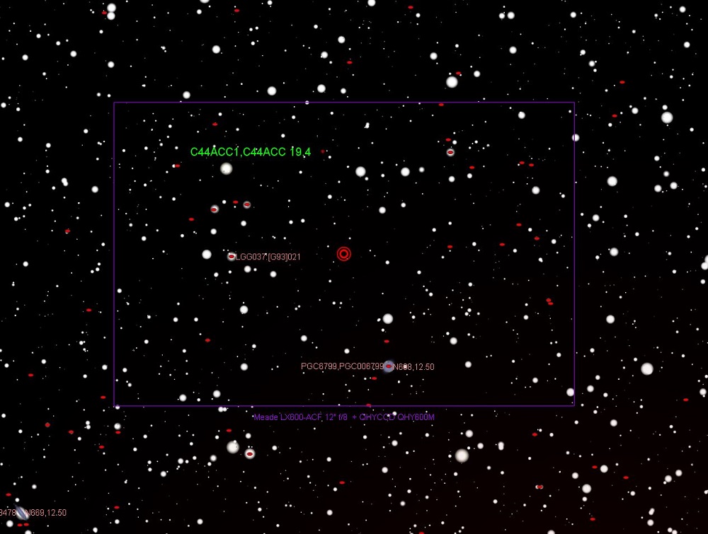
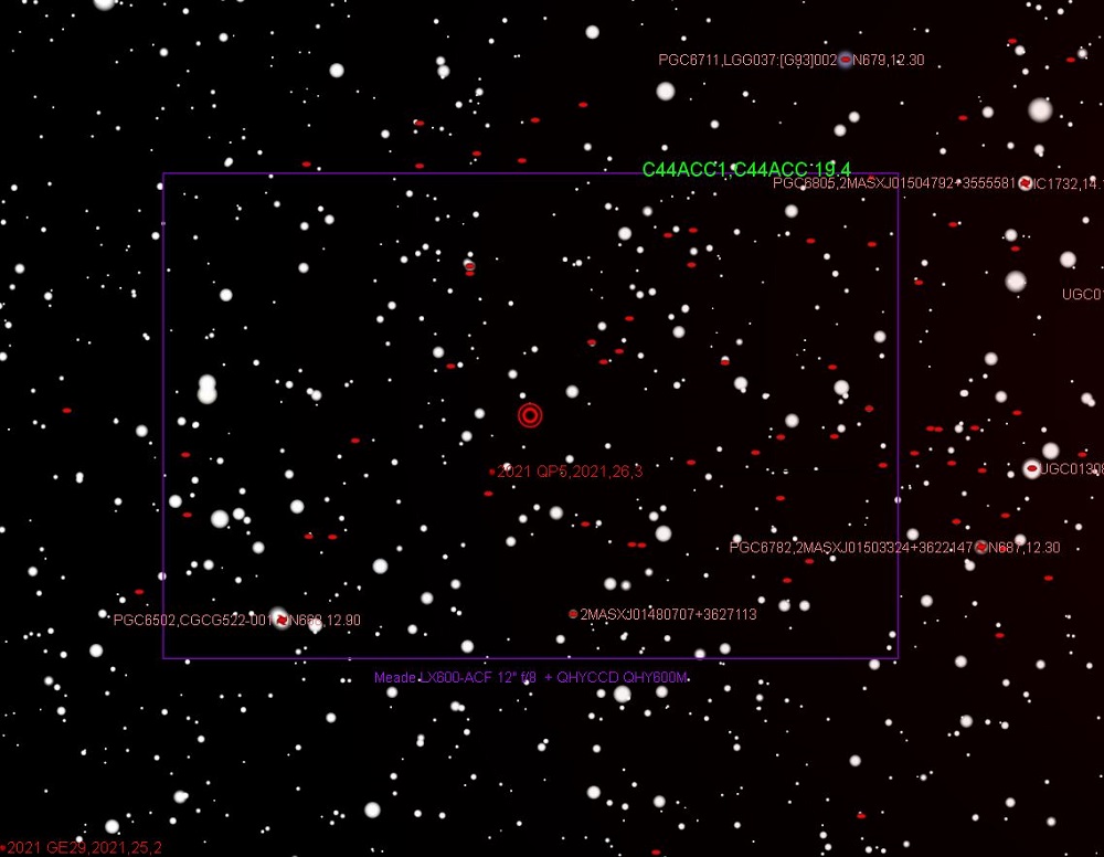
Original NEO Planner position
Position of the fast object C44ACC1 according to the plan of NEO Planner
Position of the fast object C44ACC1 according to the plan of NEO Planner
First position of the fast object C44ACC1 (40s/min in PA 350) according to the scout ephemeris, as in normal planning.
The object is shown here in TheSky X slightly above the central scout position due to the orbit elements interpreted there
and is only intended to serve as further orientation for the following mosaic positions. (Southwest is top left).
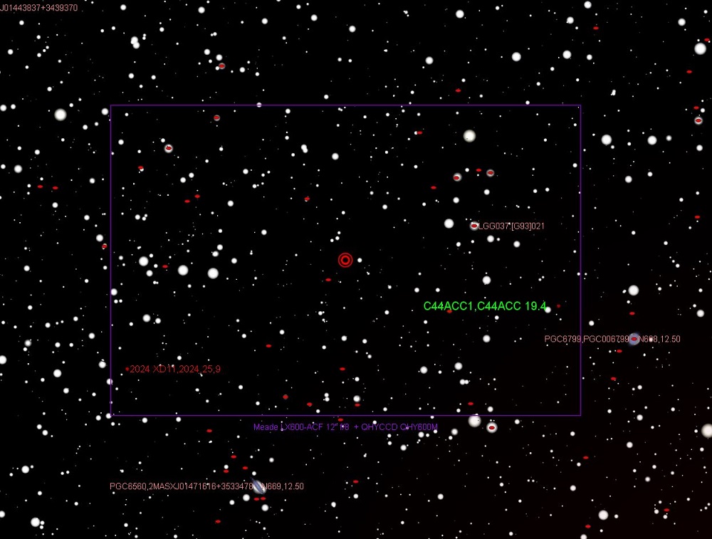
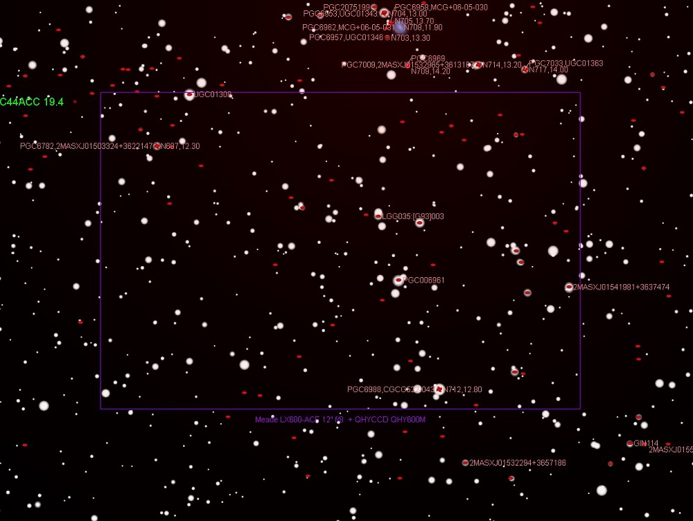
Mosaic position 1
Mosaic position 1 of the fast object C44ACC1
Mosaic position 1 of the fast object C44ACC1
At mosaic position 1, the center of the image was shifted to the southwest compared to the time-accurate central scout position.
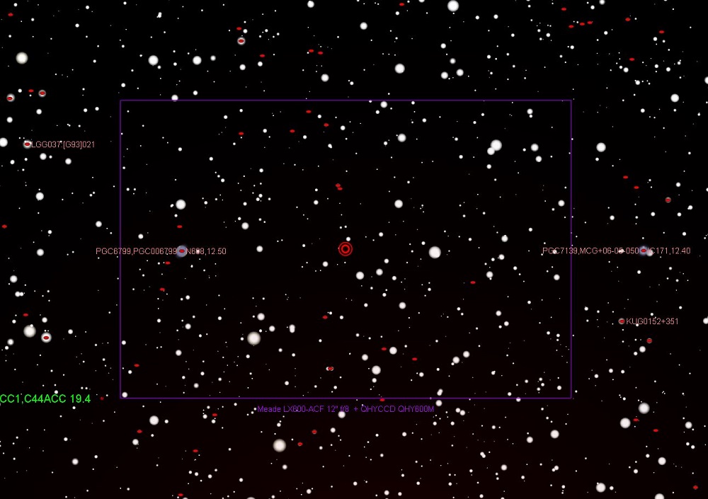
Mosaic position 2
Mosaic position 2 of the fast object C44ACC1
Mosaic position 2 of the fast object C44ACC1
In mosaic position 2, the center of the image was shifted to the southeast compared to the time-accurate central scout position.
Mosaic position 3
Mosaic position 3 of the fast object C44ACC1
Mosaic position 3 of the fast object C44ACC1
At mosaic position 3, the center of the image was shifted to the northwest compared to the time-accurate central scout position.
Mosaic position 4
Mosaic position 4 of the fast object C44ACC1
Mosaic position 4 of the fast object C44ACC1
At mosaic position 4, the center of the image was shifted to the northeast compared to the time-accurate central scout position.